


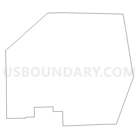
Tuscola, Sanilac & Huron Counties PUMA, Michigan
About
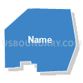
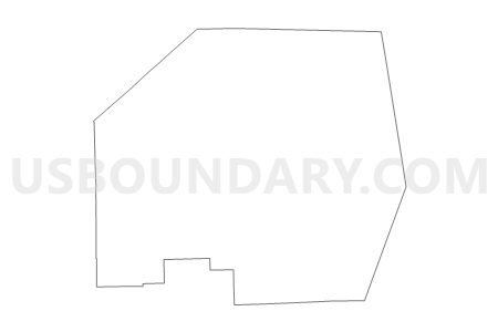
Outline
Summary
| Unique Area Identifier | 193161 |
| Name | Tuscola, Sanilac & Huron Counties PUMA |
| State | Michigan |
| Area (square miles) | 4,640.66 |
| Land Area (square miles) | 2,601.40 |
| Water Area (square miles) | 2,039.26 |
| % of Land Area | 56.06 |
| % of Water Area | 43.94 |
| Latitude of the Internal Point | 43.67357180 |
| Longtitude of the Internal Point | -82.90655930 |
Maps

Graphs
Select a template below for downloading or customizing gragh for Tuscola, Sanilac & Huron Counties PUMA, Michigan


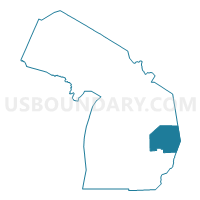
Neighbors
Neighoring Public Use Microdata Area (by Name) Neighboring Public Use Microdata Area on the Map
- Bay & Midland Counties PUMA, MI
- Genesee (East) & Lapeer Counties PUMA, MI
- Genesee (West) & Shiawassee Counties PUMA, MI
- Iosco, Gladwin, Roscommon, Ogemaw & Arenac Counties PUMA, MI
- Saginaw County PUMA, MI
- St. Clair County PUMA, MI
Top 10 Neighboring County (by Population) Neighboring County on the Map
- Genesee County, MI (425,790)
- Saginaw County, MI (200,169)
- St. Clair County, MI (163,040)
- Bay County, MI (107,771)
- Lapeer County, MI (88,319)
- Tuscola County, MI (55,729)
- Sanilac County, MI (43,114)
- Huron County, MI (33,118)
- Iosco County, MI (25,887)
- Arenac County, MI (15,899)
Top 10 Neighboring County Subdivision (by Population) Neighboring County Subdivision on the Map
- Vienna charter township, Genesee County, MI (13,255)
- Hampton charter township, Bay County, MI (9,652)
- Thetford township, Genesee County, MI (7,049)
- Indianfields township, Tuscola County, MI (6,048)
- Birch Run township, Saginaw County, MI (6,033)
- Deerfield township, Lapeer County, MI (5,695)
- Forest township, Genesee County, MI (4,702)
- Marathon township, Lapeer County, MI (4,568)
- Millington township, Tuscola County, MI (4,354)
- Vassar township, Tuscola County, MI (4,093)
Top 10 Neighboring Place (by Population) Neighboring Place on the Map
- Caro village, MI (4,229)
- Bad Axe city, MI (3,129)
- Vassar city, MI (2,697)
- Sandusky city, MI (2,679)
- Croswell city, MI (2,447)
- Cass City village, MI (2,428)
- Marlette city, MI (1,875)
- Sebewaing village, MI (1,759)
- Harbor Beach city, MI (1,703)
- Reese village, MI (1,454)
Top 10 Neighboring Elementary School District (by Population) Neighboring Elementary School District on the Map
- Bloomfield Township School District 7F, MI (243)
- Verona Township School District 1F, MI (173)
- Colfax Township School District 1F, MI (154)
- Church School District, MI (145)
- Sigel Township School District 6, MI (95)
- Sigel Township School District 4F, MI (85)
- Sigel Township School District 3F, MI (81)
Top 10 Neighboring Unified School District (by Population) Neighboring Unified School District on the Map
- Bay City School District, MI (72,031)
- Clio Area School District, MI (20,392)
- Croswell-Lexington Community School District, MI (14,438)
- Lakeville Community Schools, MI (12,000)
- Caro Community Schools, MI (11,767)
- North Branch Area Schools, MI (11,416)
- Yale Public Schools, MI (11,279)
- Tawas Area Schools, MI (11,054)
- Standish-Sterling Community School District, MI (10,351)
- Birch Run Area School District, MI (9,614)
Top 10 Neighboring State Legislative District Lower Chamber (by Population) Neighboring State Legislative District Lower Chamber on the Map
- State House District 81, MI (95,883)
- State House District 96, MI (91,648)
- State House District 94, MI (89,541)
- State House District 84, MI (88,847)
- State House District 97, MI (88,640)
- State House District 83, MI (88,414)
- State House District 82, MI (88,319)
- State House District 103, MI (86,884)
- State House District 48, MI (83,139)
Top 10 Neighboring State Legislative District Upper Chamber (by Population) Neighboring State Legislative District Upper Chamber on the Map
- State Senate District 26, MI (275,787)
- State Senate District 31, MI (255,631)
- State Senate District 36, MI (254,090)
- State Senate District 25, MI (251,359)
- State Senate District 32, MI (242,645)
Top 10 Neighboring 111th Congressional District (by Population) Neighboring 111th Congressional District on the Map
- Congressional District 10, MI (719,712)
- Congressional District 1, MI (650,222)
- Congressional District 5, MI (635,129)
Top 10 Neighboring Census Tract (by Population) Neighboring Census Tract on the Map
- Census Tract 113, Saginaw County, MI (6,903)
- Census Tract 131, Saginaw County, MI (6,033)
- Census Tract 9708, Sanilac County, MI (6,024)
- Census Tract 2852.01, Bay County, MI (5,834)
- Census Tract 3320, Lapeer County, MI (5,695)
- Census Tract 10, Tuscola County, MI (5,549)
- Census Tract 9712, Sanilac County, MI (5,444)
- Census Tract 5, Tuscola County, MI (5,429)
- Census Tract 9, Tuscola County, MI (5,311)
- Census Tract 6551, St. Clair County, MI (5,212)
Top 10 Neighboring 5-Digit ZIP Code Tabulation Area (by Population) Neighboring 5-Digit ZIP Code Tabulation Area on the Map
- 48420, MI (22,078)
- 48059, MI (15,123)
- 48723, MI (12,479)
- 48732, MI (11,483)
- 48768, MI (9,832)
- 48415, MI (9,471)
- 48746, MI (8,528)
- 48413, MI (7,551)
- 48734, MI (7,444)
- 48422, MI (6,400)